

Are you fascinated by space and astronomy? Would you like to know where the thousands of artificial satellites that orbit the Earth are located? Want to access the data they collect and transmit? Then this article is made for you ! We will present to you 5 websites that will allow you to view satellites in real time and obtain technical information about them. Whether you are simply curious or passionate about observing the sky, these websites will amaze you!
How to view satellites in real time?
satellites are generally too small and too distant to be seen with the naked eye from the Earth's surface. However, some can be seen when reflecting sunlight in the dark. This is particularly the case for the ISS , which appears as a very bright star moving quickly in the night sky.
To view satellites in real time and know their exact position , there are websites that aggregate location data provided by official sources or amateurs. These websites display a map of the world on which we can see the trajectories of satellites and click on those of interest to obtain technical information about them. Some of these websites even allow you to make a Dropped Pin on Google Maps to see the satellite in 3D and compare it with the terrestrial landscape . Here is a selection of 5 websites to view satellites in real time:
N2yo
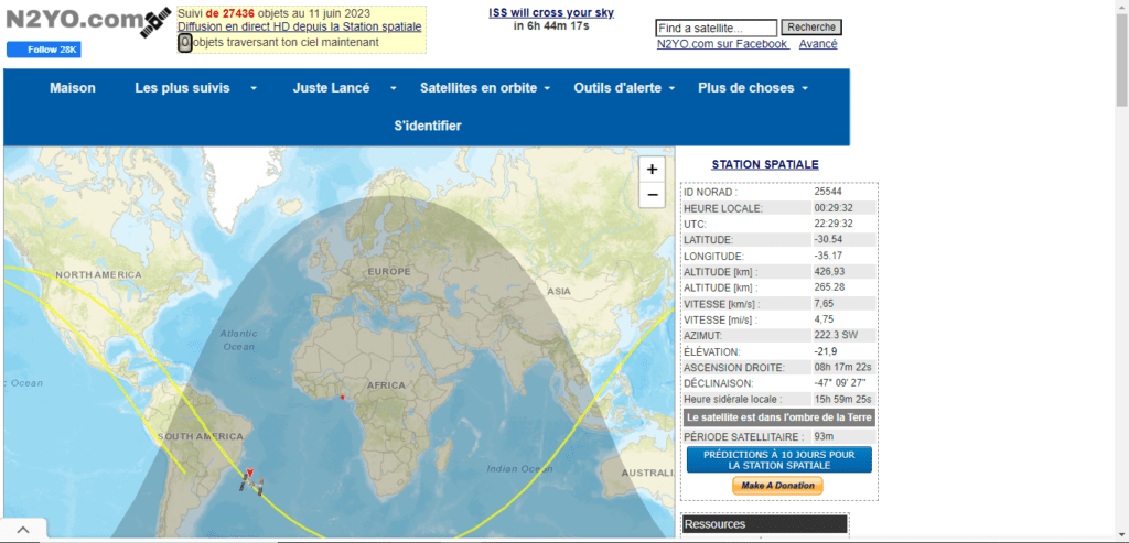
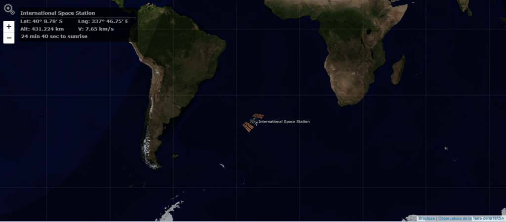
N2yo is a website that allows you to see the position and trajectory of the ISS and over 20,000 other satellites in real time. You can choose the satellite you want to track from a list that shows its name, type, country of origin and launch date. You can also search by category, region or keyword. The website displays a world map that you can zoom and pan to see satellites passing over your geographic area. By clicking on a satellite, you can see its characteristics, such as its altitude, speed, inclination or orbital period. You can also see a forecast of the satellite's visible passes from your location, as well as a 3D simulation of its orbit.
In-the-sky.org
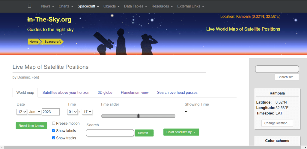
In-the-sky.org is a website that allows you to see satellites observable from your location in real time. The website automatically detects your geographic position and displays a sort of radar on which satellites appear above your horizon. You can filter satellites by type, magnitude, or elevation. By clicking on a satellite, you can see its name, altitude, distance and direction. You can also see a world map that shows the position of satellites in real time, as well as a celestial map that shows their position relative to the stars and planets.
Satmap.space

Satmap.space is a website that allows you to see satellites in real time on a full-screen world map. The website displays more than 2,000 satellites identified by colored icons according to their type. You can select the satellites you want to appear on the map from a menu that shows their name, type and country of origin. You can also search by name or NORAD ( North American Aerospace Defense Command) . By clicking on a satellite, you can see its characteristics, such as its altitude, speed, inclination or orbital period. You can also see a 3D simulation of its orbit.
Satflare.com
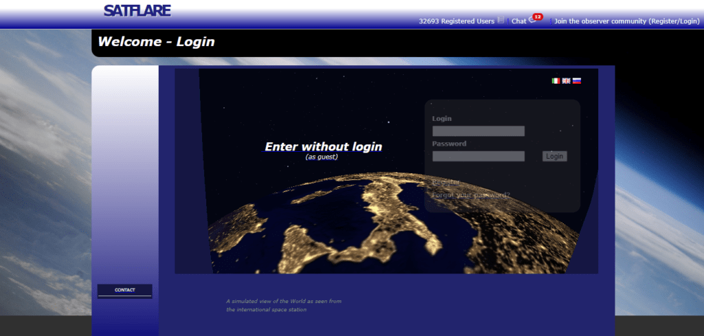
Satflare.com is a website that allows you to view satellites in real time on an interactive world map. The website displays more than 15,000 satellites identified by light points according to their magnitude. You can choose the satellite you want to track from a list that shows its name, type and launch date. You can also search by name or NORAD number. By clicking on a satellite, you can see its characteristics, such as its altitude, speed, inclination or orbital period. You can also see a forecast of the satellite's visible passes from your location, as well as a 3D simulation of its orbit.
Lizard-tail.com
Lizard-tail.com is a website that allows you to see satellites in real time on an animated world map. The website displays more than 1,000 satellites identified by icons according to their type. You can choose the satellite you want to track from a list that shows its name and NORAD number . You can also search by name or NORAD number. By clicking on a satellite, you can see its characteristics, such as its altitude, speed, inclination or orbital period. You can also see a 3D simulation of its orbit .
FAQs
What is an artificial satellite?
An artificial satellite is a man-made object that is placed in orbit around the Earth or another celestial body . It moves in a fixed path, called an orbit, which depends on its speed and the gravity of the body around which it rotates. There are different types of artificial satellites, depending on their function:
- Telecommunications satellites : they are used to transmit television, radio, telephone or internet signals. For example, the Eutelsat 16A satellite allows you to receive the TV5 Monde Afrique channel in Benin.
- Navigation satellites : they make it possible to determine the exact position of an object or a person on the earth's surface. For example, the Global Positioning System (GPS) uses a constellation of 24 satellites to provide geolocation information.
- Observation satellites : they are used to collect data on Earth or space, such as climate, meteorology, geography, astronomy or espionage. For example, the Sentinel-2A satellite takes high-resolution images of the Earth's surface for environmental applications.
- Scientific satellites : they are used to carry out experiments or measurements in space, such as physics, biology or medicine. For example, the Hubble satellite is a space telescope that observes distant celestial objects.
The first artificial satellite was launched by the Soviet Union on October 4, 1957 . It was Sputnik 1, a metal sphere 58 cm in diameter which emitted a radio signal. Since then, more than 10,000 satellites have been orbited around the Earth, of which around 3,000 are still active. The largest artificial satellite is the International Space Station (ISS) , which is 109 meters long and weighs more than 400 tons.
What was the first artificial satellite launched into space?
The first artificial satellite launched into space was Sputnik 1 , put into orbit by the Soviet Union on October 4, 1957. It was a metal sphere 58 cm in diameter which emitted a radio signal .
What is the largest artificial satellite orbiting the Earth?
The largest artificial satellite orbiting Earth is the International Space Station (ISS) , which is 109 meters long and weighs more than 400 tons. It welcomes astronauts of different nationalities who carry out scientific experiments in space.
What is the most followed satellite on real-time viewing websites?
The most tracked satellite on real-time viewing websites is the ISS , as it is easily observable with the naked eye as it passes over your location. You can see its position and trajectory on the websites we have presented in this article.
What are the benefits of artificial satellites for humanity?
Artificial satellites bring many benefits to humanity , such as:
- Facilitate communications around the world, thanks to telecommunications satellites.
- Improve navigation and geolocation , thanks to navigation satellites.
- Providing information on Earth and space, thanks to observation and scientific satellites.
- Explore the universe and its mysteries, thanks to astronomical satellites.
What are the disadvantages of artificial satellites for the environment?
Artificial satellites also have disadvantages for the environment , such as:
- Pollute the atmosphere during their launch, by emitting greenhouse gases .
- Cluttering space with space debris , which can collide with other satellites or fall back to Earth.
- Disrupt astronomical observations , by creating light reflections in the night sky.
Conclusion
Websites for viewing satellites in real time are fascinating tools for space and astronomy enthusiasts. They make it possible to track the position and trajectory of the thousands of artificial satellites that orbit the Earth and to access the data they collect and transmit. Whether for information, entertainment or wonder, these websites offer a unique and enriching experience. Among these websites, one of the most popular is Google Earth , which allows you to use satellite images to explore the world in 3D.


