

Google Maps is the world's most popular mapping and navigation service . It lets you easily find your way, discover new places, plan your trips, and much more. But did you know that Google Maps is packed with useful and fun features you might not be aware of?
In this article, we will present 10 advanced Google Maps features absolutely need to know.
1. Use Google Maps offline
Are you travelling to a place where the internet connection is weak or non-existent ?
Don't panic, you can still use Google Maps offline. Simply download the maps of the areas you're interested in before you leave. This way, you can view maps, search for addresses, get directions, and even use voice navigation without needing to connect to the internet.
To download offline maps, follow these steps:
- Open Google Maps on your smartphone or tablet
- Tap on your profile picture in the top right corner
- Select “Offline Maps”
- Tap “Select your own map”
- Zoom in or move the map to select the area to download
- Click on “Download”

You can download as many maps as you like, but be mindful of your device's storage space. You can also manage your maps offline by renaming, updating, or deleting them. Offline maps are valid for one year, after which they will be automatically deleted.
2. Create a multi-point route
Do you want to go on a road trip or visit several places in one day ?
Google Maps lets you create a multi-point itinerary, meaning you canadd stops to your route. This allows you to optimize your time and distance, and make sure you don't miss anything you want to see.
To create a multi-point itinerary, follow these steps:
- Open Google Maps on your smartphone or tablet
- Press the “Directions” button in the bottom right corner
- Enter your starting point and your destination
- Tap the three dots in the top right corner
- Select “Add a step”
- Enter the address or name of the place you want to add
- Repeat the process as many times as you want.
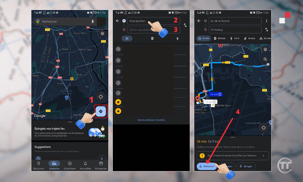
You can add up to 9 stops to your route. You can also edit or delete stops by tapping the "Edit" button in the top right corner. Google Maps will show you the total time and distance of your trip, as well as the best mode of transport to use.
3. Display the speedometer and speed limits
Are you driving on a road you do n't know and you don't know the speed limit ?
Google Maps helps you comply with traffic laws by displaying your speedometer and speed limits on your screen. This allows you to adjust your driving and avoid fines.
To display the speedometer and speed limits, follow these steps:
- Open Google Maps on your smartphone or tablet
- Tap on your profile picture in the top right corner
- Select “Settings”
- Tap on “Navigation”
- Activate the “ Speedometer ” and “ Speed Limits ” options
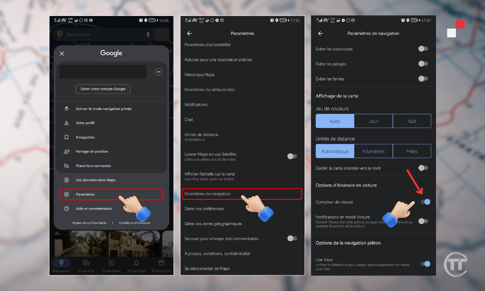
The speedometer will appear in the bottom left corner of your screen, and the speed limits will appear in the bottom right corner. You can also adjust the speedometer and speed limit settings by choosing the unit of measurement ( km/h or mph ) and the type of alert ( audible or visual ).
4. Travel through time with Street View
Do you want to travel back in time and see what a place looked like a few years ago ?
Google Maps offers this possibility through Street View, which allows you to browse photos of a place at different times. You can thus observe the evolution of a landscape, a monument or a neighborhood over time.
To travel through time with Street View, follow these steps:
- Open Google Maps on your computer
- Enter the address or name of the place you want to explore
- Click on the little yellow man in the bottom right corner
- Drop it onto the map where you want to see the photos
- Click on theclock icon in the top left corner
- Drag the slider to choose the year and month you are interested in.
You can travel through time with Street View in over 80 countries , going back to 2007. You can also navigate in augmented reality with Google Maps, using the “ Live View ” feature on your smartphone or tablet. You'll see virtual arrows and directions displayed on your screen to guide you.
5. Find the price of gasoline based on gas stations
Do you need to fill up your petrol and want to find the cheapest or nearest petrol station ?
Google Maps lets you search for nearby gas stations and compare fuel prices. This way, you can save money and time.
To find petrol prices at different petrol stations, follow these steps:
- Open Google Maps on your smartphone or tablet
- Press the “Search” button in the top left corner
- Enter “gas stations” or “gasoline” in the search bar
- Press the “Filter” button in the top right corner
- Choose the type of fuel you want (petrol, diesel, LPG, etc.)
- Press “Apply”
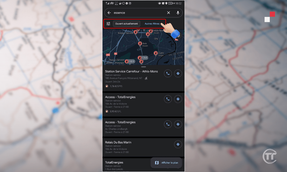
Google Maps will display a list and map of gas stations matching your criteria. You'll also see the fuel price and distance to each station. You can also filter the results by distance, rating, or opening hours.
Read also : How to find the altitude of a place using Google Maps?
6. Find nearby fast electric vehicle charging stations
Do you drive an electric vehicle and want to find nearby fast electric charging stations ?
Google Maps allows you to configure your app to indicate that you drive an electric vehicle . This will enable you to search for nearby fast charging stations and compare prices and availability.
To find nearby fast electric charging stations, follow these steps:
- Open Google Maps on your smartphone or tablet
- Tap on your profile picture in the top right corner
- Select “Settings”
- Tap on “Navigation”
- Activate the “ I drive an electric vehicle ” option
- Choose the connector type and power rating for your vehicle.
- Press “Save”
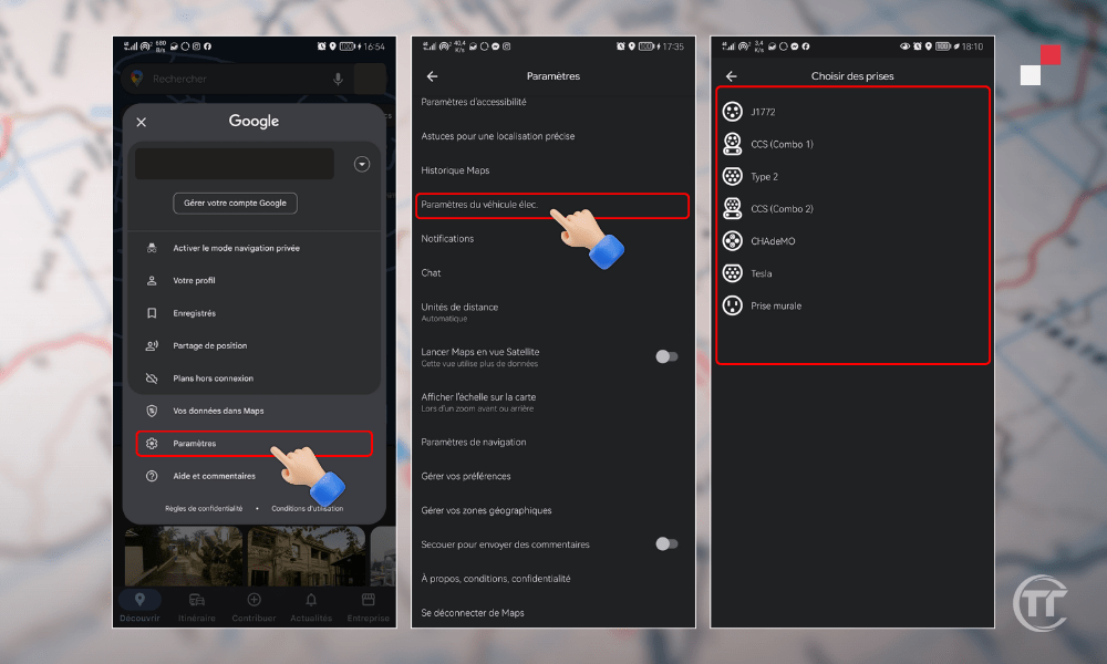
Google Maps will display a list and map of nearby fast electric vehicle charging stations . You'll also see the price, availability, and charging time for each station. You can also filter the results by connector type, power output, price, or distance from the stations.
7. Look for wheelchair-accessible routes
Do you use a wheelchair and want to find the routes best suited to your situation?
Google Maps allows you to activate the accessibility option in your app. This will enable you to search for wheelchair- accessible routes for public transport, walking, or cycling.
To find wheelchair-accessible routes, follow these steps:
- Open Google Maps on your smartphone or tablet
- Press the “Directions” button in the bottom right corner
- Enter your starting point and your destination
- Choose the mode of transport you want
- Press the “Options” button in the top right corner
- Activate the “ Accessibility ” option
- Press “Done”
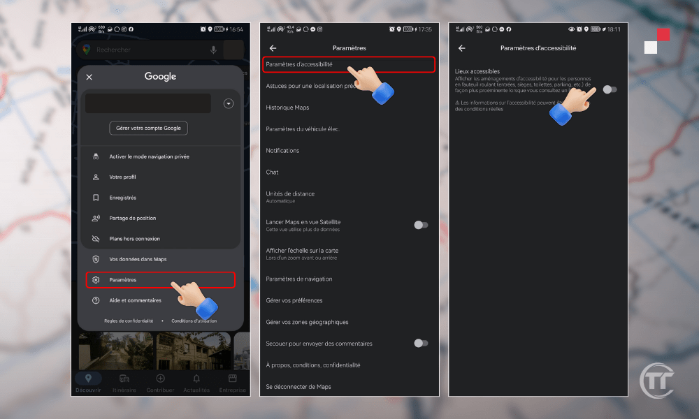
Google Maps will show you wheelchair - accessible routes for your chosen mode of transport. You'll also see information about any obstacles, slopes, elevators, or ramps you might encounter.
You can also report accessibility issues you encounter in the field by pressing the “Contribute” button in the bottom right corner.
8. Check the peak hours of a restaurant, shop or bar
Do you want to go out to eat, shop or have a drink, but you don't want to run into a crowd of people?
Google Maps lets you see the peak times for a place, meaning the number of people who visit it at different times of the day or week. This allows you to choose the best time to go and avoid queues or crowds.
To check the peak hours of a location, follow these steps:
- Open Google Maps on your smartphone, tablet or computer
- Enter the name or address of the place you want to visit
- Tap the name of the location at the bottom of the screen
- Scroll down to see location information
- Look at the graph that shows peak hours

Google Maps will show you the peak times for the location on the current day, as well as an estimated wait time. You can also see peak times for other days of the weekby clicking the "Plan" button in the top right corner.
9. Customize your car icon
Do you want to personalize your navigation experience with Google Maps ?
You can change your car icon , which appears on the map when you use " Driving " mode . You can then choose from the different options available, such as a sports car , a truck , a taxi or even a dinosaur .
To customize your car icon, follow these steps:
- Open Google Maps on your smartphone or tablet
- Press the “Driving” button in the bottom left corner
- Press the “Start” button in the bottom right corner
- Tap onyour car icon in the bottom right corner
- Choose your preferred icon from the available options.
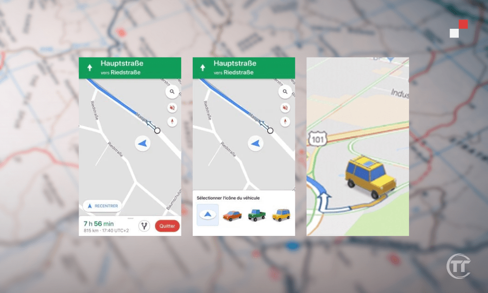
Your car icon will change immediately on the map, and you'll be able to see it move as you travel. You can also change your icon at any time by repeating the same steps.
10. Know which is the most touristy area near you
Are you on holiday in a city you don't know and you want to know which is the most touristy area near you?
Google Maps lets you use the “Discover” feature, which allows you to discover the most popular, highly rated , or most visited near you. This will help you find ideas for outings, visits, or entertainment.
To find out which is the most touristy area near you, follow these steps:
- Open Google Maps on your smartphone or tablet
- Press the “Discover” button in the bottom left corner
- Press the “Districts” button in the top left corner
- Scroll through the list of suggested neighborhoods
- Click on the neighborhood you are interested in
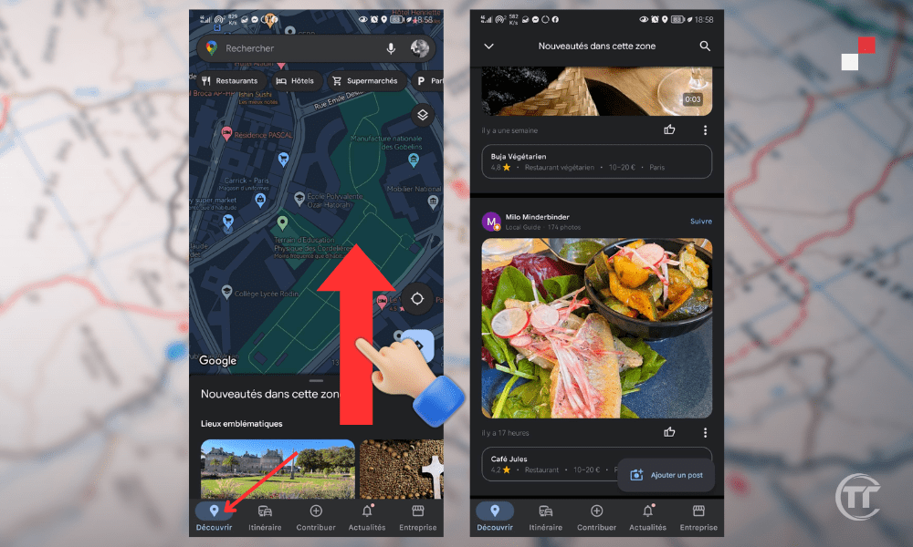
Google Maps will display a map of the chosen neighborhood, along with a selection of places to discover, such as restaurants, museums, parks, and bars. You'll also see information about the neighborhood, like its history, atmosphere, and attractions.
You can also filter the results according to your preferences or budget by pressing the “Filter” button in the top right corner.
Good to know : How to do a Dropped Pin on Google Maps from your smartphone or PC?
FAQ
How do I share my real-time location with Google Maps?
Google Maps lets you share your real-time location with your contacts, so they can see where you are and how long it will take you to arrive. To share your real-time location, follow these steps:
- Open Google Maps on your smartphone or tablet
- Tap on your profile picture in the top right corner
- Select “Share location”
- Choose the duration for which you want to share your location
- Select the contacts with whom you want to share your location
- Tap “Share”
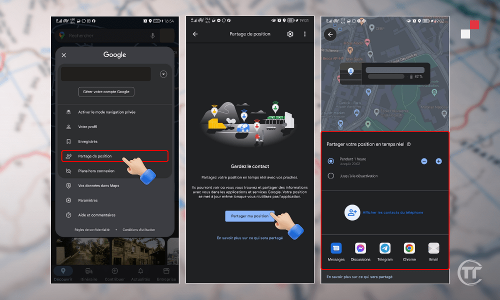
You can stop sharing your location at any time by pressing the “Stop” button in the top right corner.
How to use Google Maps to measure the distance between two points?
Google Maps lets you measure the distance between two points, whether as the crow flies or by following a road. To measure the distance between two points, follow these steps:
- Open Google Maps on your computer
- Right-click on the starting point
- Select “Measure distance”
- Move the map to choose the arrival point
- Left-click on the arrival point
Google Maps will display the distance between the two points in the bottom right corner. You can also add other points to measure more complex distancesby repeating the same steps.
How to use Google Maps to find child-friendly places?
Google Maps helps you find child-friendly places, such as parks, museums, zoos, and cinemas. To find child-friendly places, follow these steps:
- Open Google Maps on your smartphone or tablet
- Press the “Discover” button in the bottom left corner
- Press the “Filter” button in the top right corner
- Activate the “ Child-friendly ” option
- Press “Apply”
Google Maps will show you a list and map of nearby child-friendly places . You'll also see information about each place , such as opening hours, prices, and reviews.
How can I use Google Maps to find pet-friendly places?
Google Maps lets you find pet-friendly places, such as hotels, restaurants, cafes, and shops. To find pet-friendly places, follow these steps:
- Open Google Maps on your smartphone or tablet
- Press the “Search” button in the top left corner
- Enter the type of place you are looking for (hotel, restaurant, cafe, etc.)
- Press the “Filter” button in the top right corner
- Activate the “ Pets allowed ” option
- Press “Apply”
Google Maps will show you a list and map of pet-friendly places matching your search. You'll also see information about the places , such as hours, prices, and reviews.

